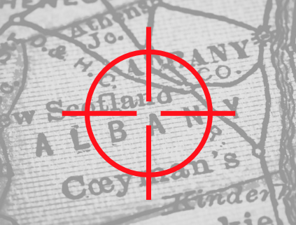
Albany, New York
September 2 - October 11 2025
Twenty-nine artists from the Albany region were invited to create maps for the exhibition at Opalka Gallery at Russell Sage College.
Read the review by William Jaeger in the Times Union.
Read a preview of the show by the 518.
Events
Compass Roses Exhibition Opening
September 12, 2025 6-9pm EST
at Opalka Gallery
140 New Scotland Ave.
Albany, NY 12208
Albany History in Maps, Talk by City Historian Tony Opalka
September 13, 2025 11am EST
at Opalka Gallery
140 New Scotland Ave.
Albany, NY 12208
Virtual Artist Talk
September 25, 2025 6-8pm EST
-

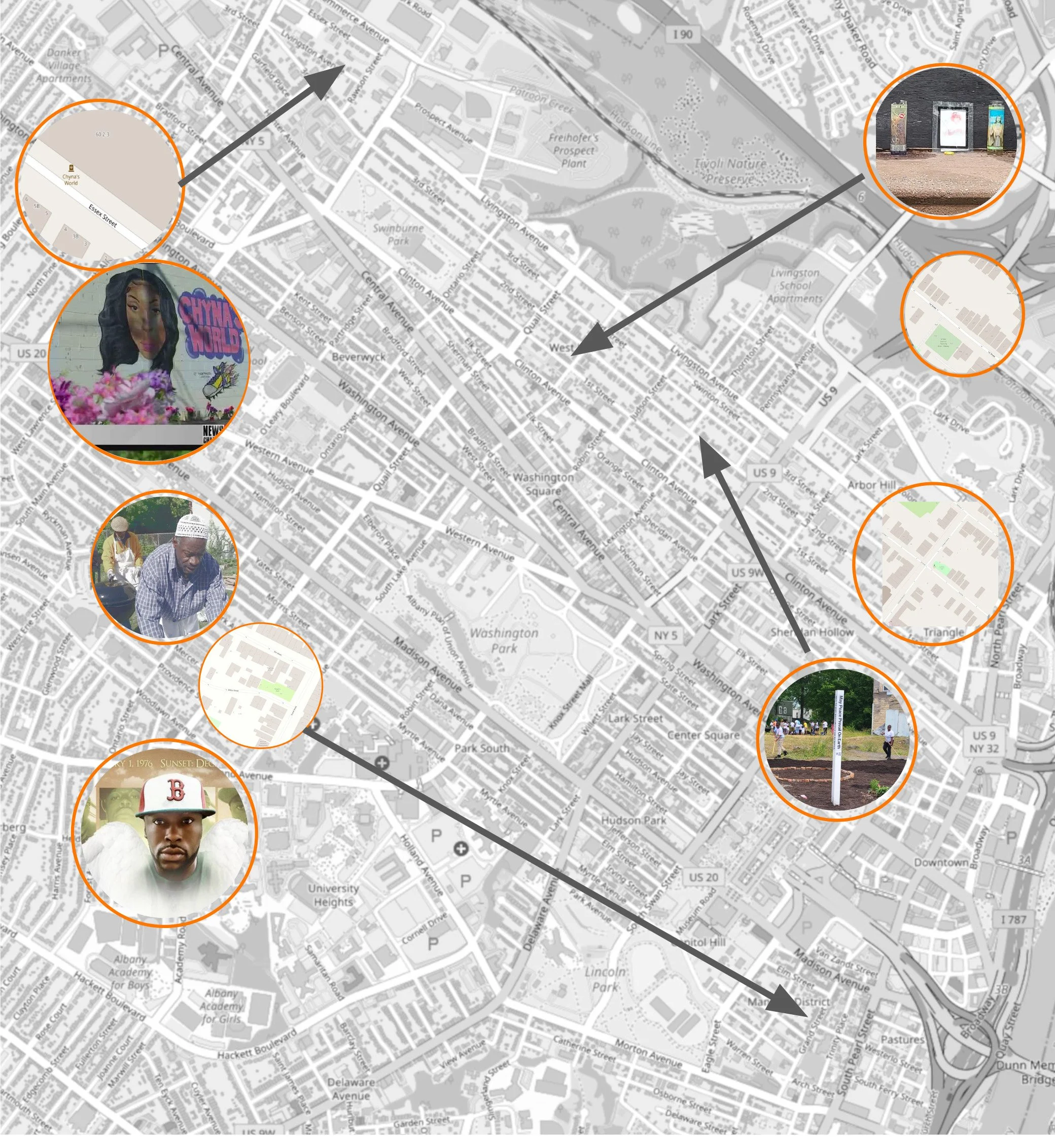
Footprints: A Map of Albany Memories
by Marcus Kwame Anderson
Being well into my 40’s, reminiscing on past experiences is increasingly commonplace for me. I’ve lived in different parts of the Capital Region, but Albany remains central in my memories. When I began the creation of my map it just made sense for it to be a map of memories. I wasn’t concerned with geographic accuracy. For example, in real life Valentine’s was south of Earthworld. The memories however, exist side-by-side in my mind.
Memories are strange. Some are solidly imprinted on us, some exist just beyond our reach as more of a feeling than an image. Most of the sites on my map are still with us. Others, like Music Shack and Valentine’s live on as invisible echoes of my formative years. These are just a handful of my favorite places. They wouldn’t all fit into what I had in mind for this composition. -
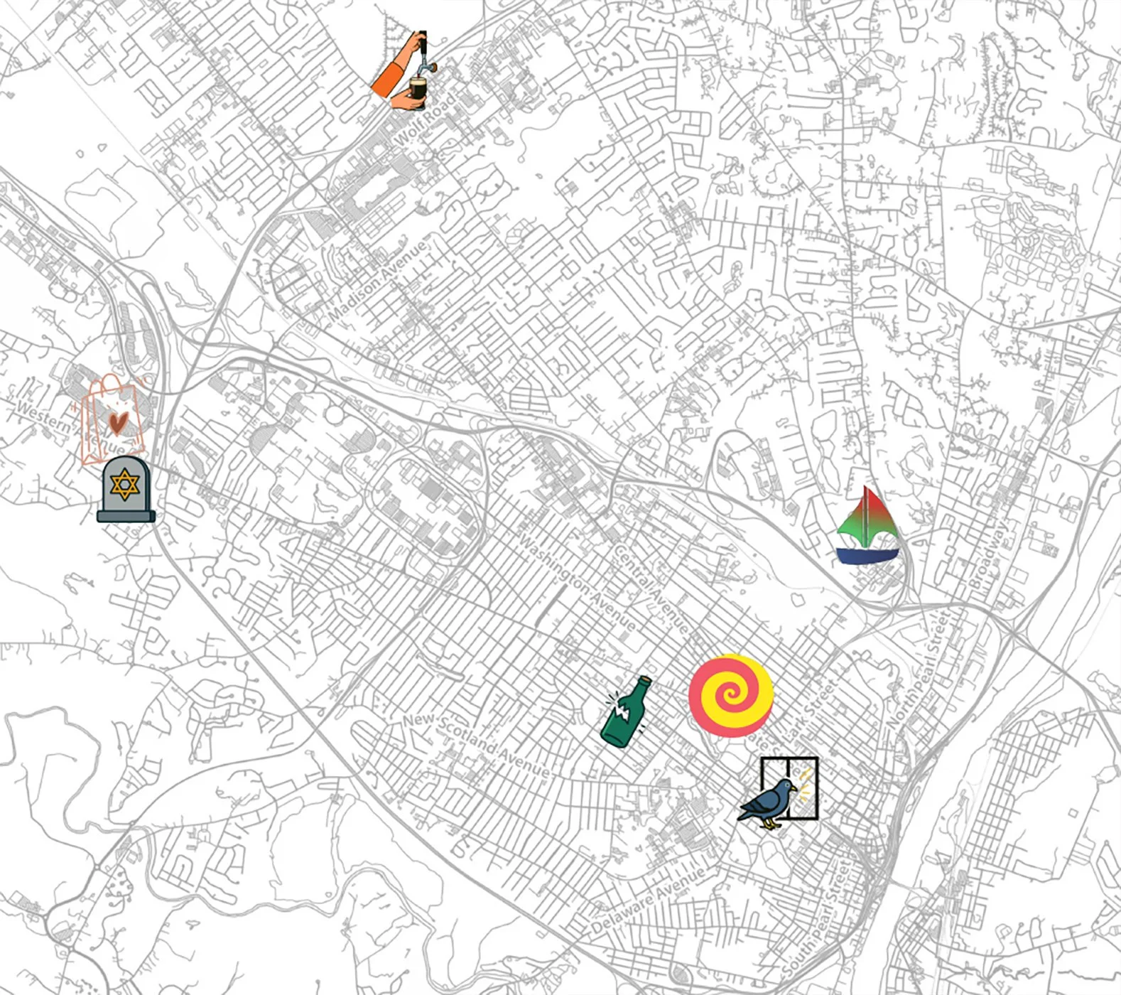
Common Monuments of a Nameless War
by Alexis Bhagat
“Violence is the most dominant subject of commemoration across the nation.” - National Monument Audit
Albany, the capital city of New York, contains a concentration of memorials to the conquest and conflicts that established and uphold the settler-colonial state. These wars have names, which are recorded on the plaques and granite bases of monuments that surround the State Capitol/Empire Plaza complex - World War II, the Korean War, the Vietnam War, etc. Beyond this complex, however, there are dozens of memorials - small and smaller - to an endless war that has no name. Since the year 2000, over 462,000 Americans have died by gun violence. This map and guide records some of the common memorials that people have painted, installed, or erected to remember loved ones who died in this war, as combatants or bystanders.
-
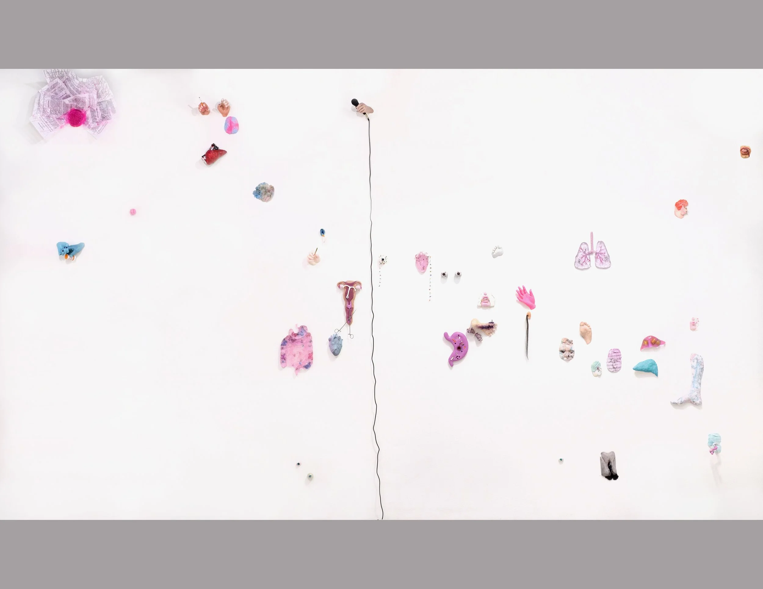
Antatomy // Atlas
by The Box Party
Often, just the idea of your favorite restaurant can get your stomach grumbling; passing the site of a great concert can sink that proverbial worm deep into your ear; walking around the campus of your alma mater reminds you of that sponge-like feeling your brain once had there, absorbing facts and figures and theories. Specific places seem to leave ghosts of themselves upon our skin, memories sinking into flesh, ideas caught in our organs, rattling around, reminding us of where we’ve been. Latitude vs longitude juxtaposed alongside burns, surgical stigmata, heartache and grief, memory-induced laugh lines, and nights inhaled to bleary-eyed mornings unslept. Marks unseen and unsung to streaks of scar tissue lead to our depictions of different lives lived within the city limits, creating an amalgamation of ourselves. The places we inhabit, the places we avoid, the cracked window pane on that one house on that one street that somehow becomes our family. These moments, this rolodex of sensory experiences, becomes a language. Traces left on the body – either intangible or literal wounds – morph into a recollection of events to form our own shared body map. Fragments act as relics, preserving moments of vulnerability, loss, and transformation. They are not meant to form a complete body, but rather to emphasize what it means to carry stories in pieces. By dislocating the body from its usual form and recontextualizing it as a fragmented cartography, the piece invites viewers to consider how we navigate the world, not just through physical space, but through feeling and memory.
-
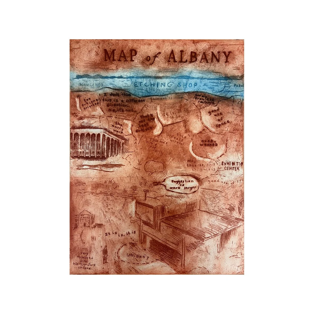
This is, This is, This is
by Leona Christie
On This etched map reimagines Albany through the emotional and gravitational pull of a familiar art department. Inspired by Saul Steinberg’s satirical cityscapes and the allegorical engravings of Goltzius and Dürer, the piece distorts geography to reflect the psychic weight of critique rooms, studio classrooms, and gallery spaces. Locations are scaled and placed according to their emotional relevance rather than physical coordinates. The map combines traditional intaglio printmaking with hand-colored watercolor and pencil, layering architecture with overheard phrases, remembered commentary, and personal landmarks. It’s both a love letter and an inside joke -- charting the terrain of art-making, memory, and institutional life.
-
Poetry Happened Here
by D. Colin
Poetry Happened Here is a mixed-media map tracing my poetic journey through the city of Albany. Each marked location represents a place where I once shared poems aloud—some still standing, others now gone. Through collage, photographs, old flyers, paint, and poetry, the map captures both memory and presence, honoring venues that gave space to creative expression. Paired with a zine featuring writing prompts and QR codes linking to audio recordings of each poem, this project invites viewers to walk the city and experience the echoes of where poetry lived, thrived, and still lingers.
-

Illium
by Alex Goss
A fictitious map of Kurt Vonnegut’s Illium. Working from within a postwar industrial boom along the postwar Hudson river, Albany, Schenectady, and Troy are refracted through the novelist’s firsthand experiences on the factory floor. This project reimagines the Capital Region through a lens concerned with the soul of a city shaped and stratified by technology and automation’s collaboration with power and capital.
By scanning the southwest corner of the printed map with your smartphone’s camera, the viewer may access a web-based, 3D version, where each point of interest holds its own little vignette of Illium.
-
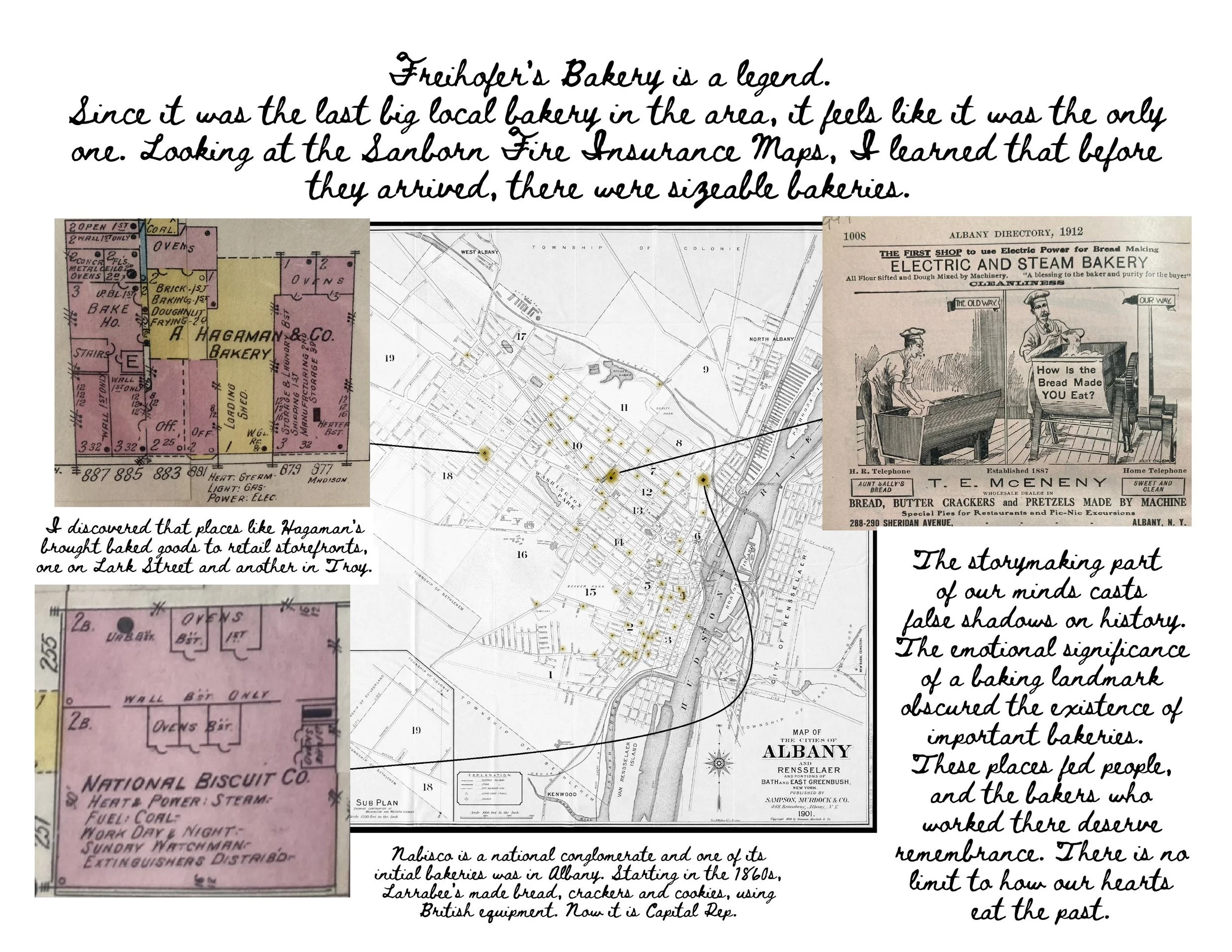
Albany Bakery Bones
by Amy Halloran
The skeleton of any city has lots of baking bones. Tracing where the ovens were, and in some cases, still are, helps bring an important part of the past, our daily bread, into the current urban context.
-

I always thought he was Neptune.
by Lori Hansen
A collage of wool and cashmere depicting Washington Park’s tulip beds from above. The park has been the centerpiece of my life in Albany. It was the view from our first apartment and is my current view from work. Everything I love about Albany is in and surrounds this park. I chose to represent the park in recycled fabric to explore the shapes of the formal gardens and represent the diverse fabric of the community surrounding the park. It took me years to learn it was Moses in the fountain.
-
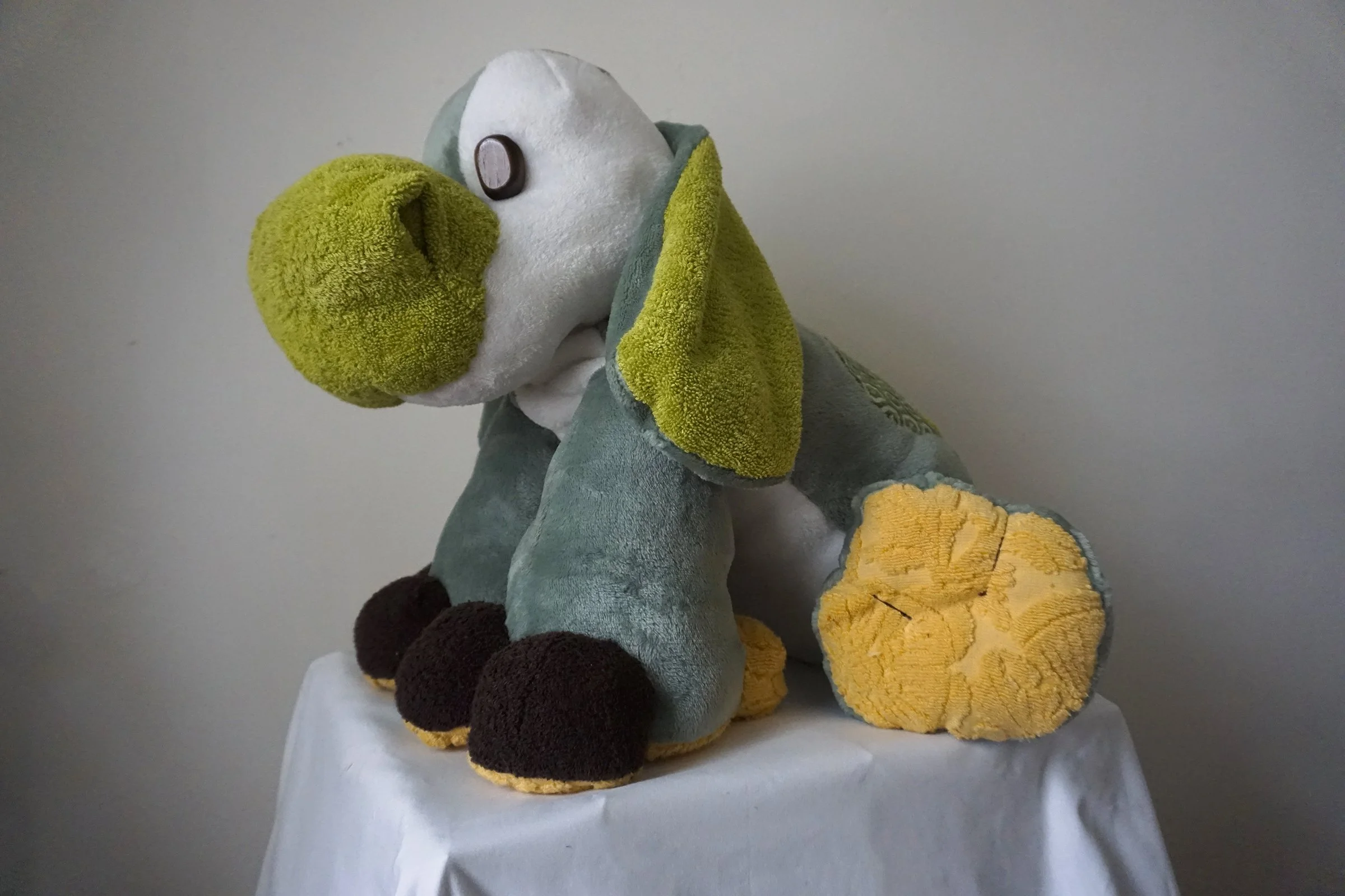
Lost Sense of Comfort
by Quill Harrison
This textile sculpture sews together the memories I made in Albany, snippets of conversations and found trinkets. All of these moments are interconnected. How the past informs the present. This stuffed animal also acts as a vessel of comfort from a time where comfort was difficult to feel.
-
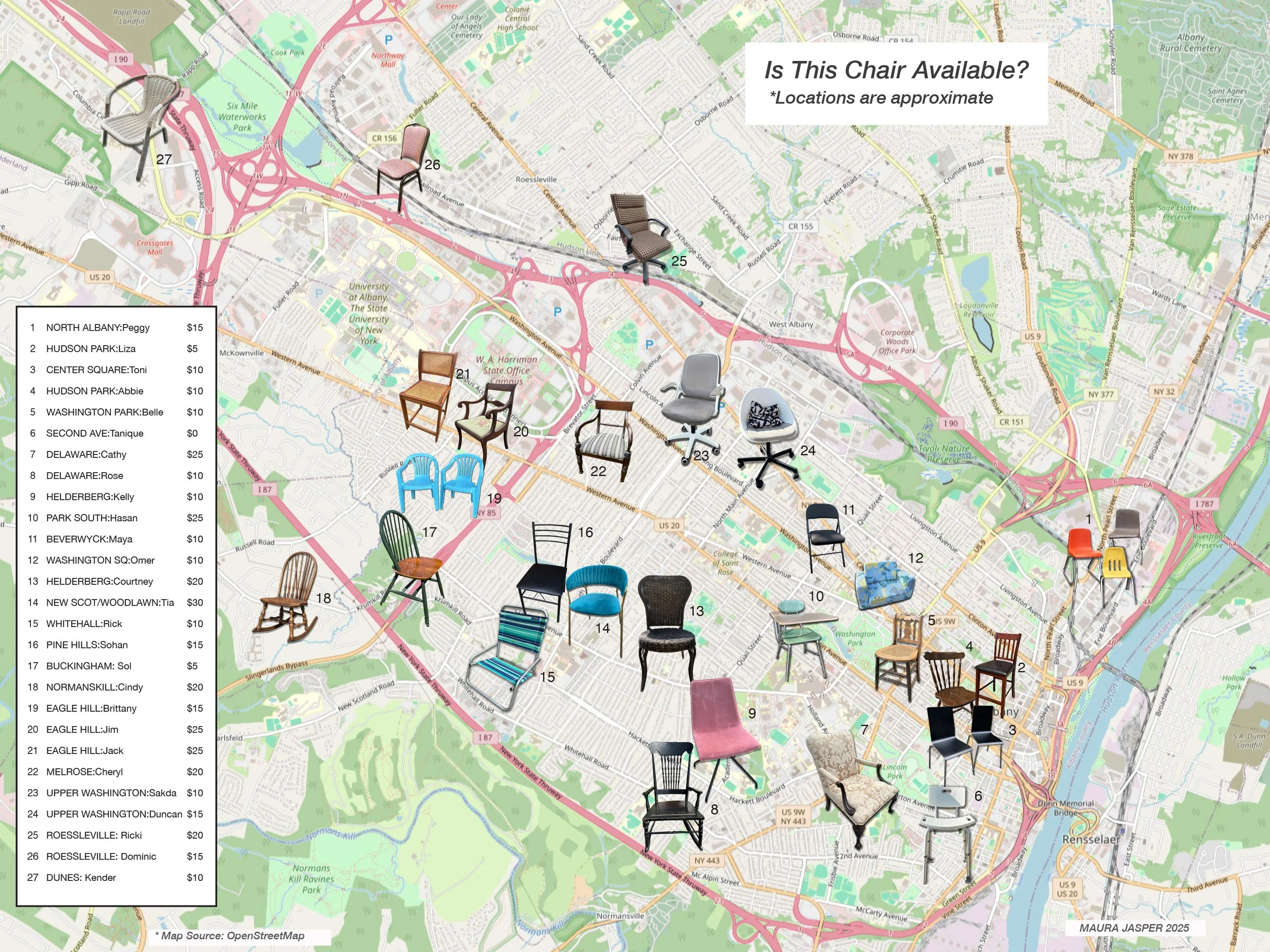
Is This Chair Available?
by Maura Jasper
(Untitled as of yet) maps Albany through secondhand chairs collected from across the city via Facebook Marketplace. Arranged according to their points of origin, the installation reflects the social, economic, and emotional terrain of place, one marked by use, memory, and quiet transactions between strangers. It is a portrait of Albany built from things left behind, exchanged, and absorbed into the lives of others.
-
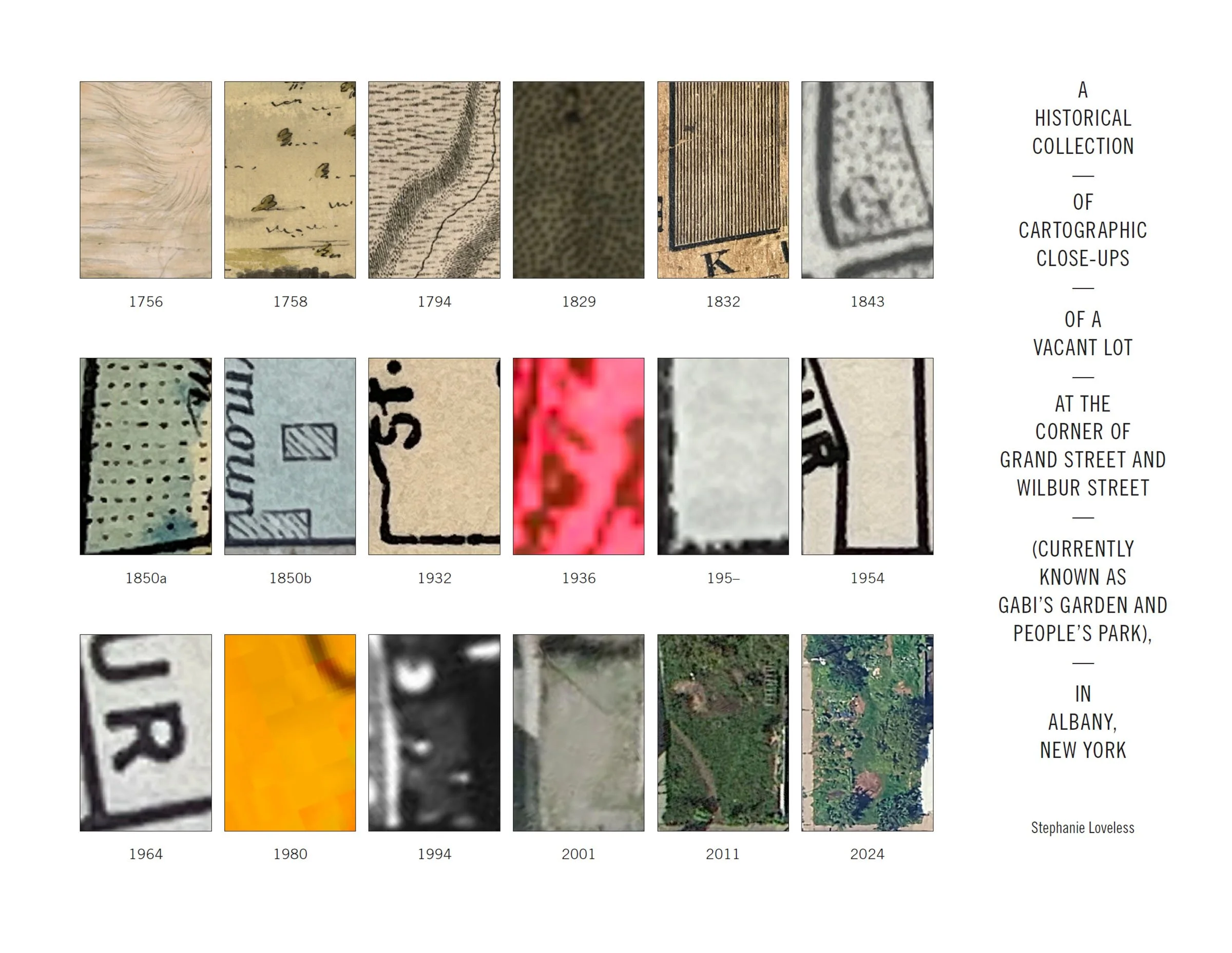
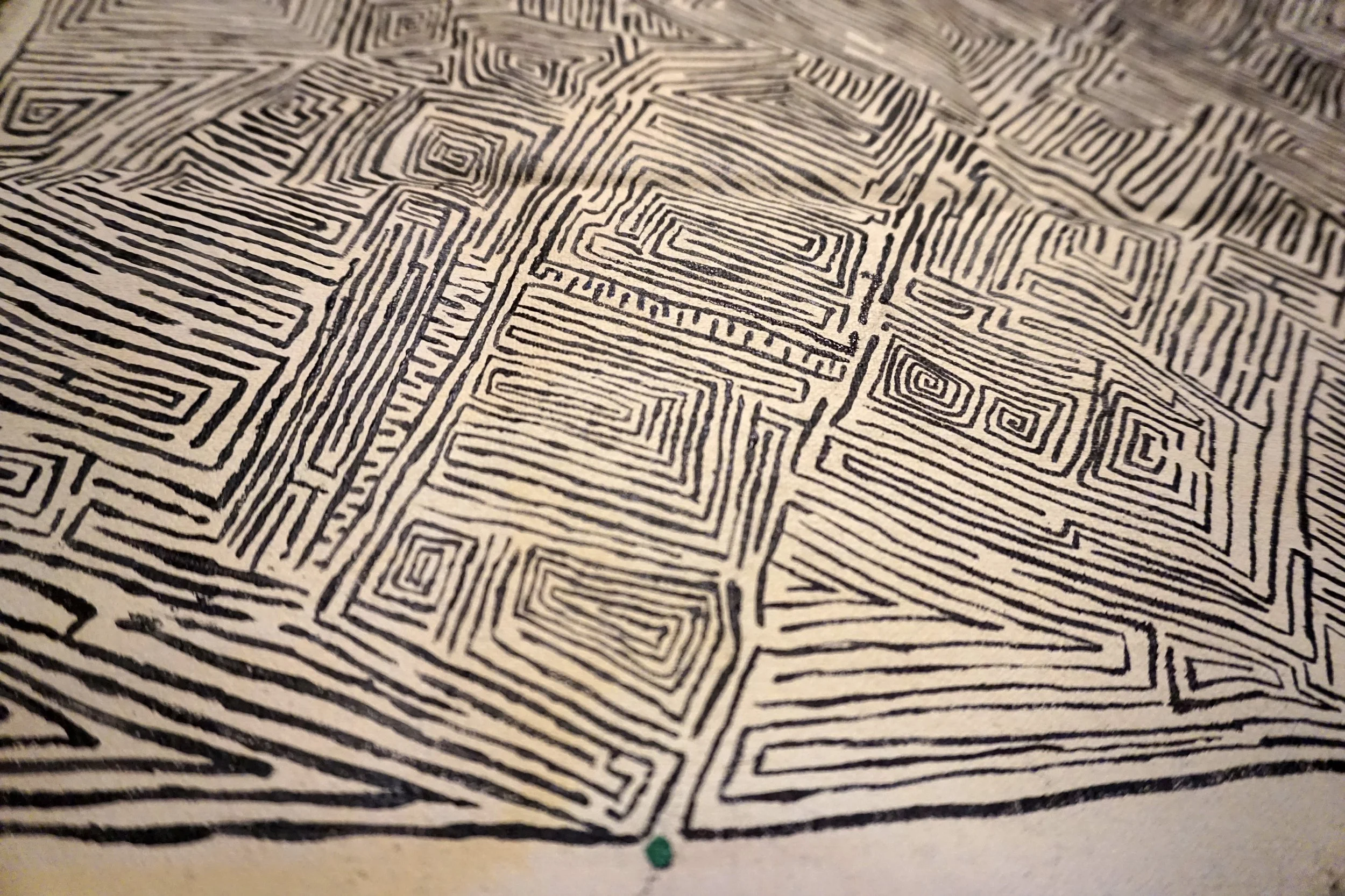
A Historical Collection of Cartographic Close-Ups of a Vacant Lot at the Corner of Grand Street and Wilbur Street (currently known as Gabi’s Garden and People’s Park), in Albany, New York
by Stephanie Loveless
This map consists of a series of extreme close-ups of maps of a vacant lot turned squatted community garden beside the artist’s home in Albany’s South End. The maps range from 18th-century cartographic surveys to contemporary satellite imaging, and depict different perspectives on the lot; a parcel of land that has been shaped by settler colonialism, redlining, “urban renewal,” utopian movements of the late 20th century, and present-day disinvestment, gun violence, community gardening, and neighborhood gathering. By looking closely at the ways this small patch of earth has been surveyed, mapped, and depicted over time, the project offers a meditation on the historical forces that continue to shape it.
-
Smell Mapping
by Jack Magai
This map is an arrangement of substances, chosen for their smell by visitors to the gallery. Visitors follow recorded directions to explore the area surrounding the gallery in search of odors, collect material, and bring it back to the gallery where it is placed on a schematic of the campus and surrounding neighborhood.
-

The River (After Wade and Croome's Panorama from New York to Albany, 1846, and Google Earth)
by Jillian McDonald
Horizontal map drawn to a scale of 1 mile to the inch, after the Wade and Croome Panoramas.
-

Sturgeontown Rangers Parade Route
by Catherine McTague
Until 1870, Atlantic Sturgeon were so historically abundant and plentiful in Albany, NY and the Hudson River, they earned the nickname “Albany Beef” and Albany was occasionally called “Sturgeontown” or “Sturgeon City.” Despite its previous quantity, the Atlantic Sturgeon was overfished in the Hudson, the magnificent creature’s population dropped, and it has been slow to recover. They are now listed as endangered and are vulnerable to human behavior and climate change, serving as a cautionary tale of not respecting the abundance and health of the Hudson River.
The Sturgeontown Parade Route is a map of the parade route The Sturgeontown Rangers took on Monday, July 4, 1870. The group formed solely to take part in parade routes and according to the Albany Morning Express newspaper, “Those in charge of the parade say that it will be the most fantastical display ever witnessed in this city,” and their parade uniform was similar to that of the ‘waterfalls’.” The group seems to have disappeared as the sturgeon disappeared, and the 1870 parade route allows the viewer to interact with and walk the route in downtown Albany, while considering the history of a very old city and how we have treated her, her river, and her wildlife.
-
Hudson Tales
by Diana Morales
This map explores the intersection of geography, memory, and connection along the Hudson River in Albany. It blends abstract expression with cartography while incorporating photos, scraps of map, and recycled materials to create a layered interpretation of the river's presence in Albany.
-
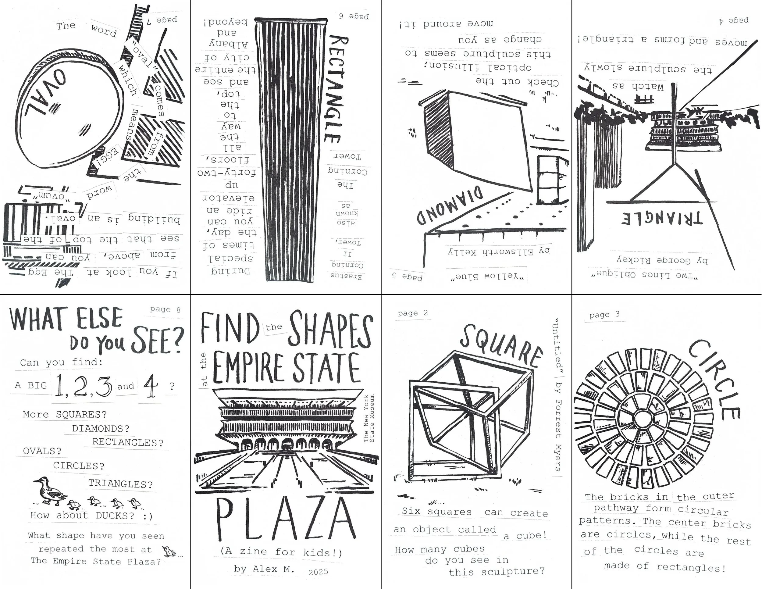
Find The Shapes At The Plaza!
by Alex Morrison
This map is intended to be enjoyed with a child on a walk through the Empire State Plaza. The space is so massive and serious, but all the basic building-block shapes that we learn as children are there if we look for them. Use the takeaway zine as a guide for a stroll through the iconic architecture, and see what you can discover!
-
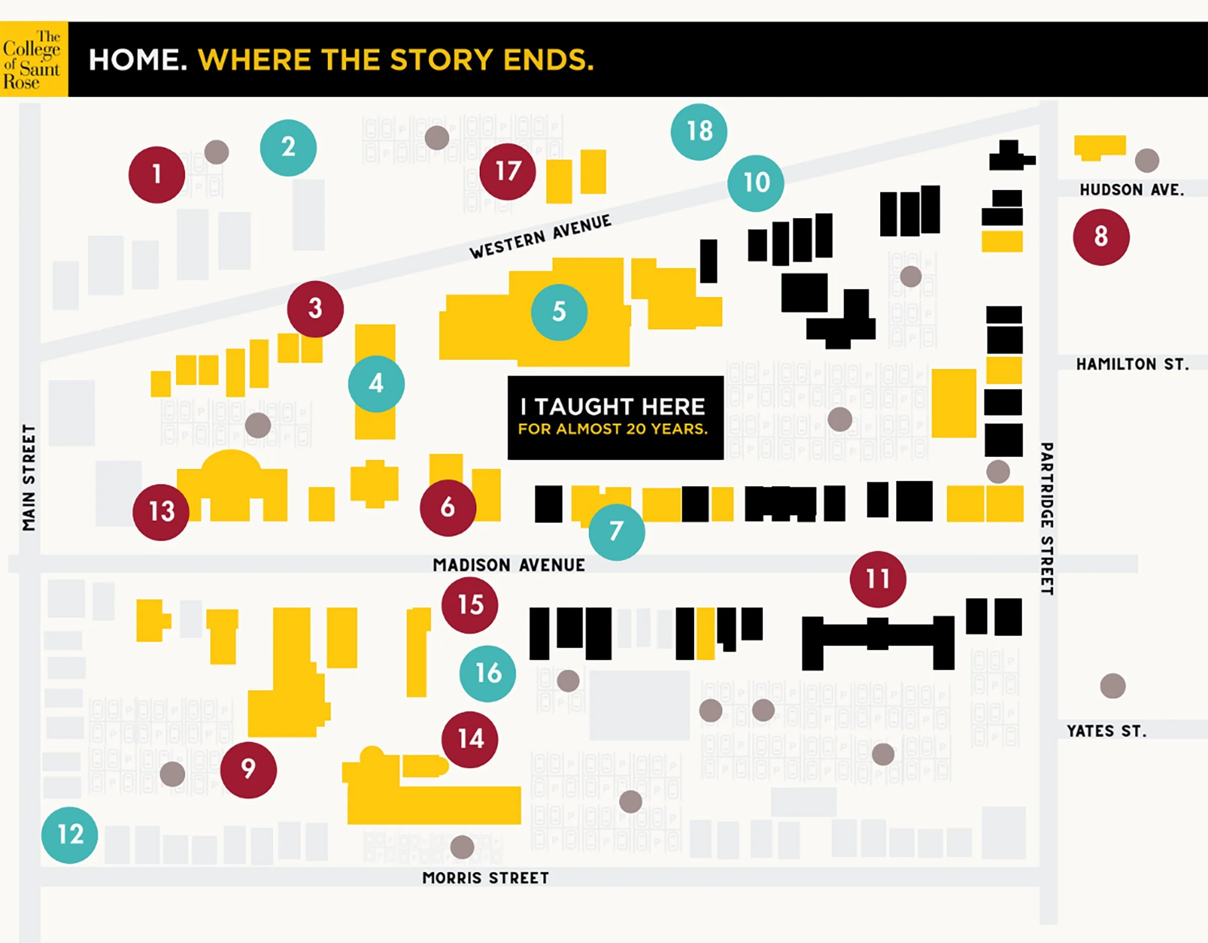
HOME. Where the story ends.
by Daniel Nester
Using a bootleg campus map, Daniel Nester charts two decades of teaching, writing, and reckoning at the now-shuttered College of Saint Rose.
-
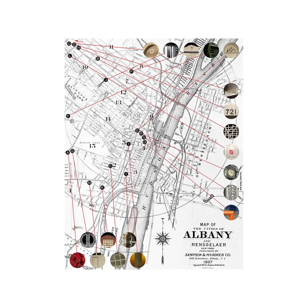
A Nocturnal Survey of Intermittently Active Time Doors in Albany, New York—as Registered by the Fortean Society, 1931-2024
by Michael James Oatman
A map with accompanying images and narrative that re-visits the unremembered Time Doors of Albany, NY.
-
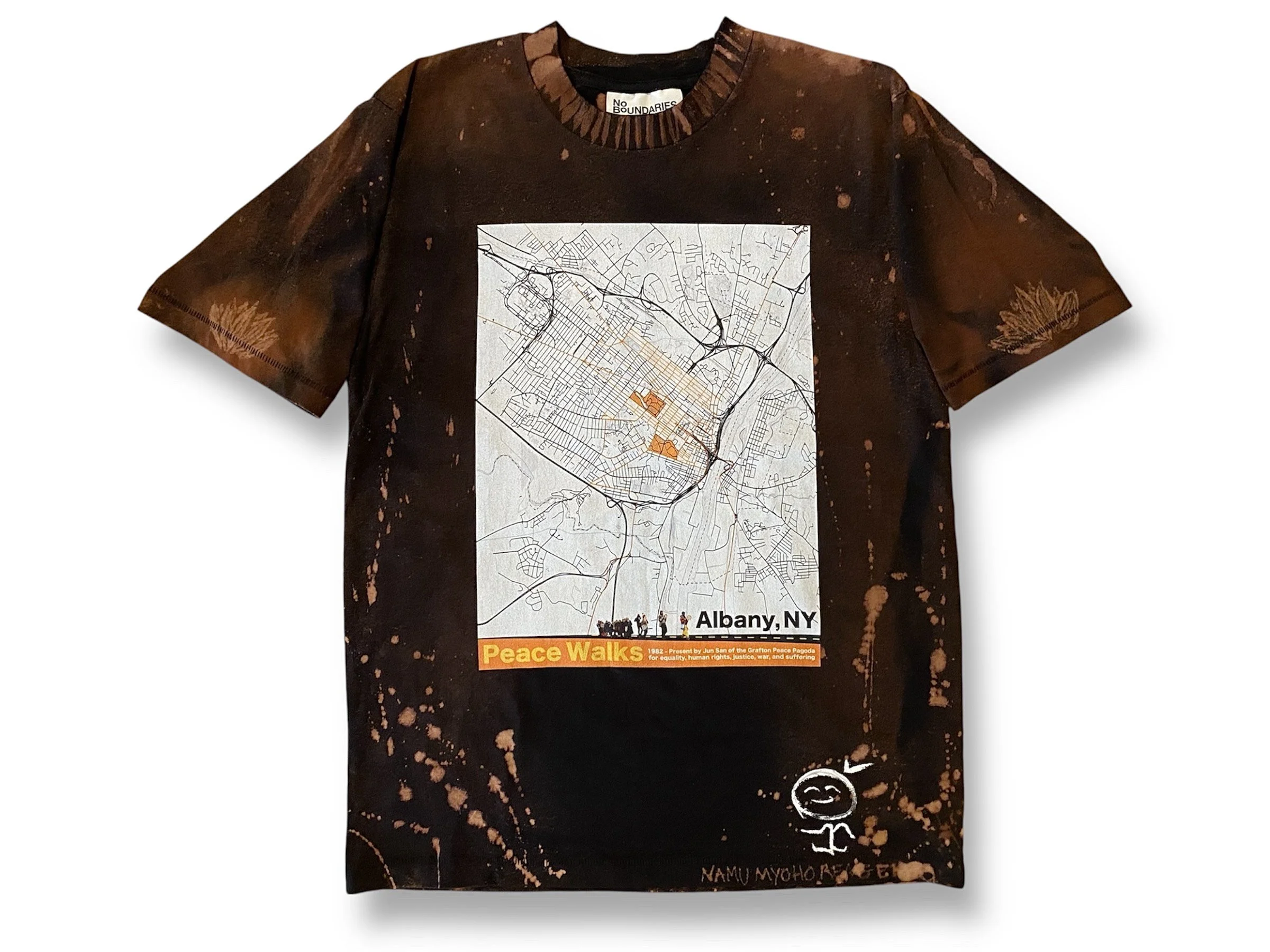
Namu Myoho Renge Kyo
by Eugene O’Neill
Jun San of the Grafton Peace Pagoda has organized Peace Walks all around the world. This is a curated map of all the routes she has walked around Albany, NY, since her first transition from California in 1982. Her walks are rooted in supporting human rights, anti-racism, anti-war, justice, equality, freedom, and honoring those who have suffered and been lost to violence. Whether alone or in groups, she remains a beacon of peace and prayer, showing up for those in need and changing the minds of those in opposition.
-
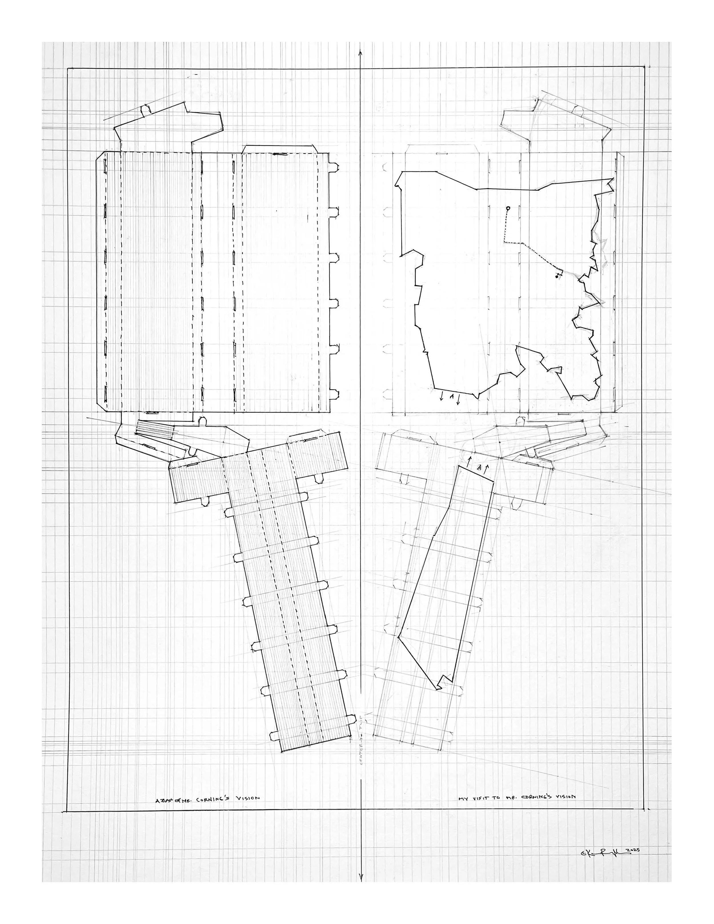
Me and Mr. Corning
by Ken Ragsdale
'Me and Mr. Corning' is a comparative description of two opposing philosophical visions for the experience of living in the city of Albany. One side illustrating grounded and digestible bits of repeatable physical experiences, and the other a remote and scaleless architectural monument to egoism and manifest destiny.
-
Take Me Home
by Mercedes Soriano
My map is a visual representation of how I felt navigating early adulthood in a town I never thought of as home. Albany is my birthplace and first “home”; half of my family originated there. After moving away for about 16 years and coming back for college, my experience living there was flooded with new situations, growing into adulthood, self-preservation, and self-exploration I am presenting my internal battle with feeling lost and confused while trying to figure out the next step in life as a growing young adult in Albany.
-
Coordinates: A Cartography of Confession
By Sarah Michelle Sherman
My map is a portrait of Albany told through memory, emotion, and experience. It’s not a guide to where to go—it’s a record of where I’ve been. A map of what was felt more than what was seen. It traces heartbreak, trauma, grief, identity, and moments of transformation. In many ways, it’s a walking confessional.
I worked with NordicCollection on Etsy to realize the final map.
-
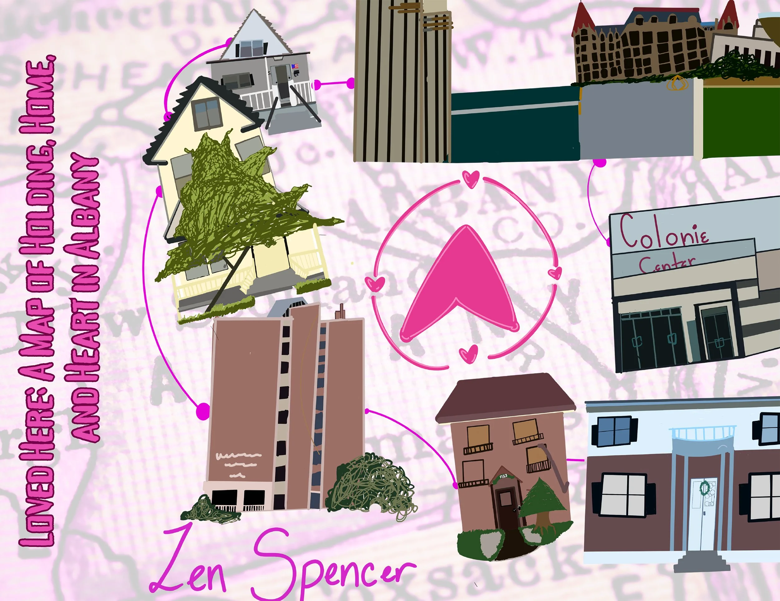
Loved Here: A Map of Holding, Home, and Heart
By Zenzele Spencer
My map is a digitally hand-drawn exploration of personal memory, home, and belonging in Albany. Using layered color, imagery, and flowing lines, the piece traces emotional landmarks—places where she has felt held, seen, and loved. Blending abstract cartography with intimate storytelling, the map reclaims space through a disabled Black girlhood lens, offering both a personal geography and a universal call toward softness and care.
-

Mansion Alternatives
By Karley Sullivan
Compass Roses: Mansion Alternatives is a reflection on the layered histories embedded in Albany’s maps and a celebration of my neighborhood's grassroots response to the socioeconomic disadvantages embedded in the planning of the NYS Capital City. The heart of the project is a living archive of alternative projects in Albany's Mansion District, which includes a growing digital record, a physical installation at Opalka Gallery, and a walking tour. Use the QR code above to access the project webpage, which will be updated on a regular basis.
There you will find links to references and a Google Maps tour of alternative and grassroots projects that have been cultivated here since the 1960's. You can also explore how those organizations intersected and shared space with each other. Locations range from The Free School, the oldest independent inner city alternative school in the United States, to contemporary initiatives like Radix Ecological Center and Kiddie Pool, the residential project space for art that I'm fostering here (with a little help from my neighbor friends).
-
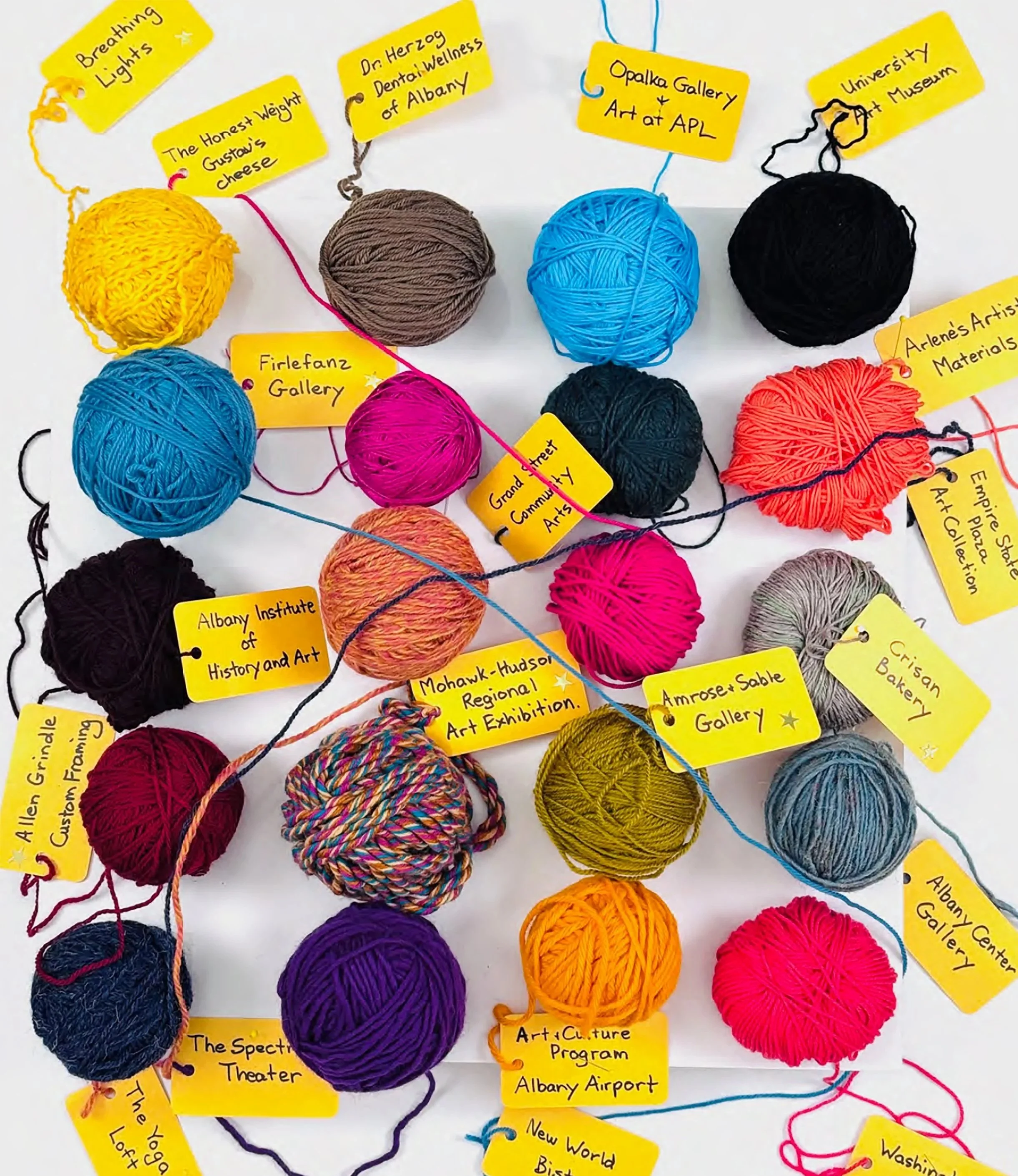
Twenty places in Albany that helped a reluctant Canadian transplant fall in love with the Capital District over two decades
By Barbara Todd
This tangle of yarns identifies Albany locations that have enriched my life in the U.S.
-
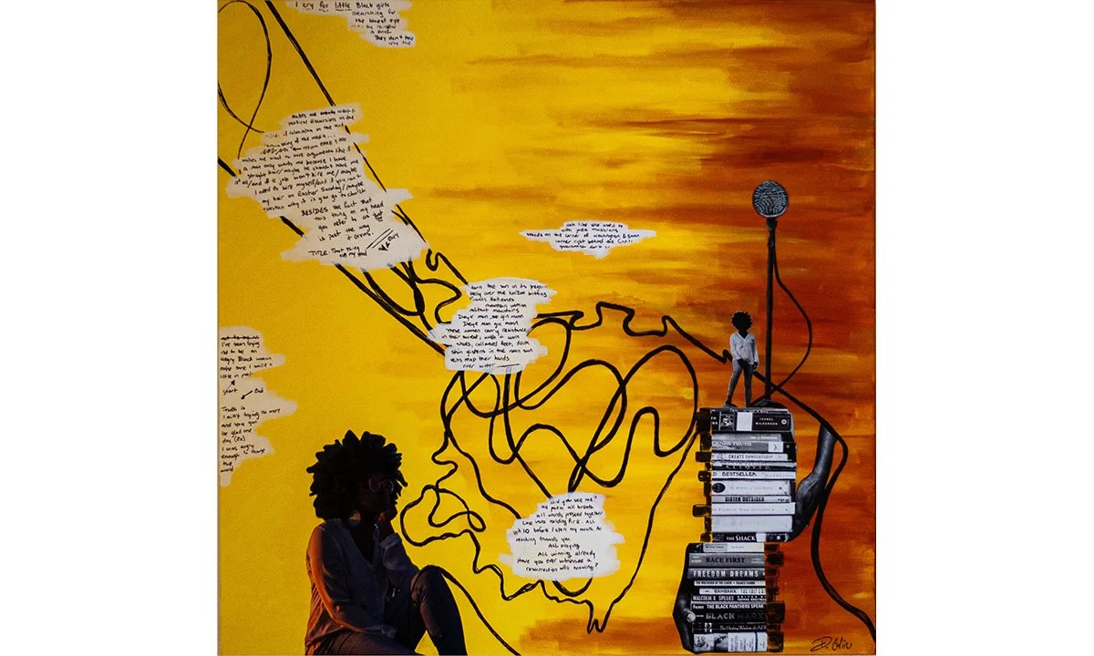
Unseen Routes: A Speculative Cartography of Black Albany—Remembered, Erased, and Imagined
By Aiesha Turman
The map is an abstract, non-geographic digital cartography that traces Black Albany across time, memory, and possibility. Organized using the BaKongo Cosmogram, it unfolds in four thematic quadrants—Memory & Foundations, Thriving Black Presence, Erasure & Violence, and Speculative Futures—inviting viewers to engage with what was, what is, and what might still be.
-

Typhoid's Takeover
By Typhoid Mary (Theo Vasilakos) & Daniel Lee
Inspired by Lana Del Rey's "Doin' Time" music video and the classic movie "Attack of the 50 Foot Woman" (1958), drag artist Typhoid Mary (Theo Vasilakos) with the help of photographer Daniel Lee, has created a piece to showcase the goals she's achieved. She is depicted stepping over The Egg, one of the most well-known performing arts centers in the Capital Region. One of Typhoid's early goals with drag was to perform on that stage. She was able to achieve that goal and put a pin on the map of her career in the fall of 2023 when she performed there with Drag Race alum for the Witch Perfect show. This piece is to commemorate that night, but also to showcase how far they have come creatively on their drag journey. As a drag artist, many times your mug (or face) will change over time, as with any artist's style. We see her here with her most current mug and aesthetic (as of 2025) to symbolize and show the continued growth as their drag journey continues. By stepping over the Egg, it showcases that a goal has been met and they are continuing to move forward while still remembering and honoring their past goals.
-

Olfactory Occurrence Map
by Allie E.S. Wist
This olfactory occurrence map (referencing the types of occurrence data maps used for tracking specimens in natural science settings) is comprised of smells in the Albany area across space and time. While some of the specimens are related to various histories and politics, many others are the result of "smell walks" or meditations conducted with colleagues and friends in Albany. These smells combine into a map of Albany as an atmosphere, and many of them speak to larger divisions of race and class. Noxious smells produced by waste incineration, for example, was historically the burden of communities of color in Albany, while restaurant smells on Central Avenue speak to the city's immigrant communities and New York State immigration policies. Other smells speak to the flora, fauna, and geology of Albany, including asphalt "rocks" or tar, ornamental plants, street trees, and animal excrement. I propose that we might consider these as "specimens" of urban ecologies-in-the-making.
Most specimens or objects in a traditional natural history museum are visual in nature—things which are preferred for their static or inert nature (often as a result of death or removal from an ecological system), as opposed to the ephemeral or the sensory. But our chemical senses (taste and smell) can be deeply informative of phenomena in our local ecologies, as is well known to many indigenous communities, despite the dismissal of this knowledge in Western modes of knowledge production. The subjectivity and corporeality of olfaction does not preclude it from being a valid form of knowledge of our environment, and in fact, may be a benefit to understanding the lived realities of ecological collapse. In the nineteenth and twentieth centuries, smell was a legitimate way to understand environmental changes, as toxic industrial pollution was frequently reported via its noxious odor. Smell provides evidence of manufactured risks that may be unperceived by the naked eye, pervasive in late industrialisms. Paying attention to smells can also be a beautiful kind of sensory "noticing practice," as encouraged by scholar Anna Tsing, which asks us to have intimacy with the world(s) we inhabit.
-

Tulips and Cacao
By Elizabeth Zunon
This map of Albany is a creative interpretation of the physical places that led to the creation of my family: from where my grandparents got married, to where my parents met and places we have habitually returned to.
Compass Roses: Maps by Artists - Albany
Opalka Gallery, Russell Sage College
Albany, New York
2025